
Silver Mountain Bike Park - is there a better descent in the world?
WOW - Lithium Trail - Teton Pass, Jackson Wyoming
The not so enjoyable part of Mountain Biking in Whistler
Bottom of the World - Surviving Whistler Top to Bottom
Conquering Whistler's Top of the World Trail
Fantasy Enduro - Enduro World Series Fantasy Game
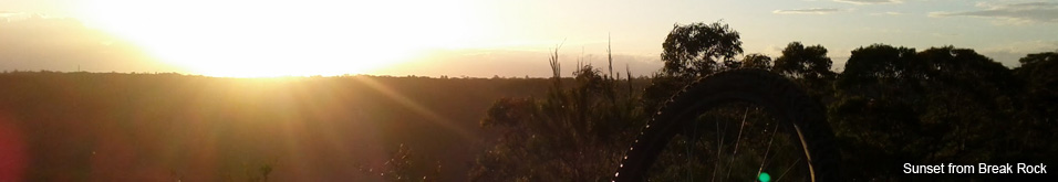
Is the Thredbo AM Trail the best descent in Australia?
MTB Trail Videos - Trail Centre Upgrade Program
VIDEO: The Fourth 365 Days of Reign - My 4th year of Mountain Biking
Pilot Wilderness Ride - Cascade to Pinch - Part 2
Pilot Wilderness Ride - Cascade to Pinch - Part 1
MTB Workout for the Deskbound
Finding Bruce Ridge and Loving It!
VIDEO: Top XC Rides of 2014/2015
VIDEO: 2015 The FAIL Awakens
VIDEO: Nine Days in the Rotorua Redwoods
Exploring all of Sparrow Hill and the East Kowen Forest
VIDEO: 365 Days of Reign - The Third (year of serious mountain biking)
The New Majura Pines and Sparrow Hill Trip
Mountain Biking in the NSW Snowy Mountains
Long term test: Yakima Highroller and Whispbar roof rack
Travelling tips for Mountain Bikers
VIDEO: Giant Anthem 29er vs Giant Reign 26
VIDEO: 2014 FAILS - Will Ride, Will Fail
VIDEO: MTB-TVs TOP 10 Descents of 2014
VIDEO: The Opening of the Alpine Epic Trail - Mt Buller
VIDEO: Wrapping up the Redwoods with a Whak-en Outrageous Ride
VIDEO: Return to the Redwoods Part IV - Eagle vs Shark
VIDEO: Return to the Redwoods Part III - XC Lower Mountain Pedally Days
VIDEO: Return to the Redwoods Part II - Heavily Rooted
VIDEO: Return to the Redwoods Part I - We're Going To The Redwoods
Video: Return to Rotorua ... ok to go!
Video: Return to Rotorua ... definitely maybe!
Video: Return to Rotorua .. maybe?
Cycology - Cycling inspired clothing
Broken Bone on Breakout
Mountain Bike Fail to Triumph in the You Yangs
365 Days of Reign - My 2nd Year on a real mountain bike
Review: the Bionicon C-Guide V2.0
Brake disk rotor size upgrade 180 to 200mm, 160 to 180mm
VIDEO: Rotorua Redwoods - Create Breathing Space
Rotorua - a Mountain Bikers Journey
Summer Mountain Bike Training at OMV
2013 Another Year of #FAIL
We're going to ride the Rotorua Redwoods
My god I love riding Stromlo Forest Park
Merry Christmas from MTB-TV - What a year its been
How to view web based KML files on your mobile device
Epic Brake Bleeding Solutions - Avid Brake Bleed Kit
The Lone Wolf enjoys some group action
Bantry Bay (Northern Beaches, Sydney)
Bruce Ridge (Canberra)
Bungarra Alpine Centre (Snowy Mountains)
Currumbin Border Track (NSW/QLD Border)
Daisy Hill (South Brisbane)
East Kowen (Kowen Pine Forest, Canberra)
Forest Pipeline (Northern Beaches, Sydney)
Fred Caterson Reserve (Castle Hill)
Golden Jubilee Field MTB Park (North Shore, Sydney)
Hassans Walls (Lithgow)
Hinze Dam (Gold Coast)
Jackson (Jackson)
Jindabyne (Snowy Mountains)
Kiwarrak State Forest (Tarree)
Majura Pines (Majura, Canberra)
Manly Dam (Northern Beaches, Sydney)
Mt Joyce (Gold Coast Hinterland)
Mt Kosciuszko (Snowy Mountains)
Nerang State Forest (Gold Coast)
Newnes (Lithgow)
Old Man's Valley (Hornsby, Sydney)
Ourimbah (Central Coast)
Oxford Falls (Northern Beaches, Sydney)
Pilot Wilderness (Snowy Mountains)
Red Hill (Northern Beaches, Sydney)
Rotorua Redwoods (New Zealand)
Silver Mountain (Kellogg)
Singleton (Hunter Valley)
Sparrow Hill (Kowen Pine Forest, Canberra)
St Ives and Belrose (North Shore, Sydney)
Stromlo Forest Park (Canberra)
Terrey Hills (Northern Beaches, Sydney)
The Oaks (Blue Mountains)
Thredbo Resort (Snowy Mountains)
Thredbo Valley Trail (Snowy Mountains)
Whistler Bike Park (Whistler)
Wingello (Southern Highlands)
Wylde MTB Trail (Cecil Park - Western Sydney)
Pilot Wilderness Ride - Cascade to Pinch - Part 1
It was years in the dreaming and months in the planning, a single day XC MTB adventure heading into the remote Australian alpine wilderness.
The Pilot Wilderness ride otherwise known as Cascade to Pinch is a 57km ride along fire trails from Dead Horse Gap just a few kms past Thredbo on the Alpine Way to the Pinch Campground located in some really wild and remote country an hour and half drive down Barry Way from Jindabyne in the NSW Snowy Mountains.
In this article I talk about the preparation and my first (and failed) attempt at the Pilot Wilderness ride. Alternatively you can go straight to Part II to read about the journey and watch the videos
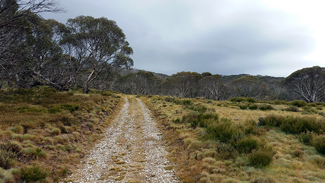
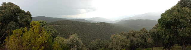
The Cascade Trail looking toward Dead Horse Gap
The Why
The adventure and exploration of some pretty unique country had enormous appeal, despite the fact that long distance riding is really not my thing. Thus far my longest ride, 47.9km, was achieved in the Kowen Forest where I never travelled more than a couple of kms from the trail head. Spending a day riding a remote fire trail that would take me further away from civilisation with every pedal stroke was quite an unusual thing for me to do - but there was a reason. Something that was very much my "kinda thing".
Along the route would be some amazing descents, two epic ones in particular. The first I'd done previously when I rode as far as the Cascade Hut, a good 10 minute descent with some fun corners and fast straights; the other was at the very end and it would be a descent like no other - 1000m drop over just 5.8km down the Nine Mile Trail! That sounded like my kind of riding! That is what would motivate me to ride 50+km into the middle of nowhere!
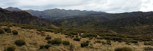
The Cascade Trail looking over the Big Boggy on the way up to Bobs Ridge.
The question many people asked is why would I attempt to do this alone? Doing it alone, pushing myself out of my comfort zone, tackling various challenges, overcoming fear and doubt, forcing myself to be disciplined and to make wise decisions when fatigued are what makes a trip like this an adventure. I felt that if I did this trip with others it would take away from the adventure and would just be a long ride with a nice view.
Also, to put this in perspective, while researching the trip I found other riders had completed this trail as part of a ride that was more than double what I would attempt. Riders who departed from Lake Crackenback and rode via the Pilot Wilderness all the way back to Jindabyne in one day. For me that would be a 2-3 day journey assuming I could actually make the distance. This ride on the greater scheme of things was not so outrageous, however for me it would be an epic adventure with reasonable risk and well beyond anything I'd attempted on my own before.
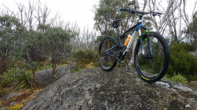
The Devils Kitchen is not 30m behind my bike and I couldn't see it
The Planning
There was some but not a lot of information on the web. The challenge was to put together a realistic picture of the journey by filtering out the key pieces of information from the stories and legends, information I continued to gather right up until the day before my departure. That being said almost all my intel came from journeys completed many years earlier, some up to a decade ago, so the information was hardly definitive.
To add additional complexity some of the information had been contradictory, most notably on the drinkability of the water and the difficulty of the final descent.
But this was to be an adventure so at some point I had to say "I guess I'll find out when I get there".
Probably the most important piece of intel was gathering the GPS tracks. I plotted the route on Google Earth along with other key pieces of information such as huts, trail intersections and other landmarks. Information I translated to a run sheet broken down in segments with distances and estimated times, which in turn was committed to memory (Trail Notes and KML).
What I was up against
I registered my trip with the NPWS in Jindabyne and in return they gave me a Personal Locator Beacon (PLB) otherwise known as an EPIRB. While there was no charge to borrow it, a PLB is a single use emergency beacon that not only carries a large fine if used in a non-life threatening situation, it also has a $1000 fee if set off! However if something really went wrong I had the right equipment to call in the emergency crews.
Along the route were 3 wilderness huts. If I had to walk out due to a major mechanical or upper body injury I could easily bunker down in a hut and survive the night in front of the fire. I wasn't going to starve and I wouldn't dehydrate in sub 10°C. Barring some tragic calamitous screw up I was confident I could survive the journey and a night in a wilderness hut if required.
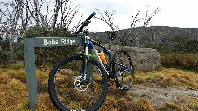
Bobs Ridge the highest point on the Cascade Trail
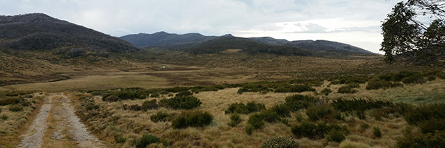
To be honest my biggest concern was for my support crew, Mum and Dad. They would drop me at Dead Horse Gap at 8am, I would be able to get an SMS out at the top of Bob's Ridge one hour later but after that I would not be able to contact them for the remainder of the journey. My parents on the other hand would be waiting at the pickup point an hour's drive out of mobile coverage. If I was seriously delayed, had to camp overnight or had to turn back I would not be able to get a message to them. What were they to do if night fell and I hadn't turned up? The non-life threatening scenarios were things I'd not considered until the night before departure and it kept me up all night as it did my Mum.
On the morning of departure we discussed our concerns and altered the plan which was now for my support crew to stay within mobile range until the last moment and importantly if I was to go on this journey then I had to be bloody sure I would make it.
Of course the key to arriving at an agreed time was to come up with an ETA with some level of accuracy. I'd been given estimates of anywhere between 7-10 hours however times on Strava varied anywhere from 5 to 9 hours. I spent quite a bit of time Strava-stalking riders who had completed the journey, comparing their speeds on trails we'd both ridden. I compared my average speed along the same route as far as the Cascade Hut and applied my speed-over-time from a previous long distance adventure at the opening of the Alpine Epic trail. I spent many hours putting this altogether allowing for plenty of stops and fluctuations in speed as I expected to be walking a lot of hills. My estimate of somewhere between 6 and 6.5 hours was conservatively stretched out to 7 hours on-trail including stops.
Departure day
I'd had the worst night sleep, worrying about everything that could possibly go wrong, mostly about my parents being in a panic if I was late, but also the warning from my bike mechanic that the river crossings can be deep, armpit deep.
As we drove past Thredbo it started to rain and the thought of crossing swollen creeks in freezing conditions started to prey on my mind. As we arrived at Dead Horse Gap the heavens unloaded. The rain was not forecast, it was supposed to be a mainly fine day with a chance of rain about 2pm, but that was Thredbo, by then I would be 50km away and coming to the end of my ride. The only thing that got me out of the car was the knowledge that I'd ridden in similar freezing wet conditions on the first section of this trail to Cascade Hut and it wasn't dissimilar to the weather I experienced when riding the Alpine Epic Trail.
The desire to ride was already fading but when I realised I'd left my GoPro behind my motivation plummeted. A slight lifting of the clouds and the thought that I'd dragged my parents all the way up to Dead Horse Gap first thing in the morning was what motivated me to put foot to pedal.
About 3/4 up the climb to Bob's Ridge the rain started again, this time it was torrential. Water was flowing down the trail, I was wet through and so cold. About 1km short of the peak I decided I would pull the pin at the top and ride back down.
The weather was looking very ominous on the way up to Bobs Ridge
There had been a roller coaster of emotions thus far and it wasn't over, at the top of the climb was a completely different weather picture. To the south over Geehi and to the north over Thredbo the skies were almost completely clear with only a small patch of cloud to the south west. It looked like it was going to be the day that the weather forecast had predicted. Back-flipping I texted Mum - I'm pushing on.
I began layering up for the long descent to Cascade Creek but as the minutes rolled by a cloud mass in front of me went really dark before unloading with great vengeance. The mountains I had seen running 50km off into the distance disappeared and shortly after the mountains nearby disappeared as well. The menacing cloud mass was not only heading toward me it was running in the direction I would be travelling for the next 6 hours. The thought of riding in the freezing rain was very unappealing but the concept of wading across swollen creeks in sub 10°C was scary if not downright stupid. I had little more than a best guess on my ETA, I really didn't know how the trail would hold up in the wet nor how the weather may change (it shouldn't have been raining as it was). There were far too many uncertainties. The rational choice was to pull out.
While I felt like a wuss, I justified my decision by repeatedly telling myself that I didn't want to be the report on TV where everyone says WTF was he thinking going out in weather like that.
I texted - Pulling out - torrential rain setting in, too dangerous.
Making the best of a bad lot
The climb up to Bob's Ridge is a bugger of a climb and not something I plan on doing again in a hurry so rather than heading straight back I decided to spend some time up there and find the largely unknown Devil's Kitchen.
Devils Kitchen
I became aware of the Devils Kitchen, a large rock shelter, when clicking on Google Earth pictures (the location later confirmed on the Kosciuszko Huts website) but on-trail there are no signs nor is there a clear track leading to it, nor is it mentioned on any maps I've found. If not for a small rock formation on the side of the trail, that may or may not be a cairn, there's nothing to alert you of its presence. In fact it took a couple of checks of the GPS for me to locate it even when I was only 30m away. Despite being about 20m long and 3m high it's surprisingly hard to find. There are quite a lot of large boulders in the area and you could literally walk straight past it if you didn't approach from the right angle.
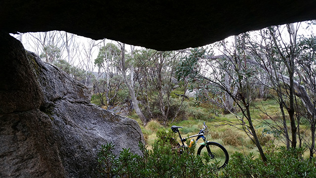
From inside the Devils Kitchen. I'm standing which gives you a good indication of the size of the shelter.
After a brief photo session and some food I followed animal tracks back in the direction of the fire trail and rode back up to Bob's Ridge.
The descent from Bob's Ridge to the Alpine Way is one of the great fire trail descents. Fast, heaps of water bars, a mix of high speed and tight corners, varying track surfaces and a couple of creek crossings. It's a great run and well worth the climb up at least once.
From Dead Horse Gap I rode down the Alpine Way to Thredbo before jumping on the TVT all the way to the Lake Crackenback Resort. A ride down that took about 2 hours and racked up 38km for the day (including the climb up to Bobs Ridge). Despite not having any rain from Bobs Ridge all the way to LCR it wasn't until Thredbo Diggings that I felt the warmth return to my fingers and toes. (Strava Ride)
The rest of the day was spent self-justifying the choice to pull out, reassessing the overall plan and opting to drive down to the Pinch Campground to scope out the rendezvous point. A good decision!
Google Map driving times are usually spot on but this trip was WAY OFF. The 55 minute drive took over an hour and a half. About 30 mins from Jindabyne the road turned to dirt, the first 20 mins or so was horrendously potholed and despite being in a Prado 4WD the trip was punctuated with emergency stops for holes big enough cause damage.
The final part of the journey was a narrow dirt road, reasonably well graded with only the odd pothole, however it was crazy. Slow blind corners, soft edges, no guard rails to stop you disappearing several hundred metres down the side of the mountain and rarely wide enough for two cars. Throw in a stack of Kangaroos, the ever present concern of wild horses and 4WDs with trailers coming the other way - it was quite the drive.
Oh .. and if for any reason you are thinking of riding back up to Jindabyne (some do), the first hour of the drive is up hill with almost no reprieve - that's drive .. not ride, 1 hour DRIVE UP HILL! Choose wisely!
From the Wallace Craigie Lookout.
You can see the road you would have to ride up from many hundreds of meters below, if you were to ride back to Jindabyne.
Safely arriving at the Pinch Campground we were surprised to find a massive camping area with room for hundreds of tents. There were a number of picnic shelters and pit toilets on either side of the Pinch River and over the other side of Barry Way was the Snowy River. Not a bad place to have a picnic or spend a few days especially if you like to fly fish.
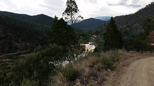
The Snowy River from Barry Way, maybe a kilometre up from the Pinch Campground.
The day had not been wasted. We felt like we had a better understanding of what were up against, better plans and we watched the thunderstorms follow the route I would have otherwise have spent my day riding.
The following day the weather was not much better but the forecast for Monday was superb, so I reregistered my trip with the NPWS, reacquired the PLB and prepared for a second attempt.
Go to Part II to read about the successful trip and watch the videos
Links To Info
Trail Centres and Trails featured in this blog
- East Kowen (Kowen Pine Forest, Canberra, ACT)
- Jindabyne (Snowy Mountains, NSW)
- Pilot Wilderness (Snowy Mountains, NSW)
- Thredbo Resort (Snowy Mountains, NSW)
- Thredbo Valley Trail (Snowy Mountains, NSW)