
Silver Mountain Bike Park - is there a better descent in the world?
WOW - Lithium Trail - Teton Pass, Jackson Wyoming
The not so enjoyable part of Mountain Biking in Whistler
Bottom of the World - Surviving Whistler Top to Bottom
Conquering Whistler's Top of the World Trail
Fantasy Enduro - Enduro World Series Fantasy Game
Is the Thredbo AM Trail the best descent in Australia?
MTB Trail Videos - Trail Centre Upgrade Program
VIDEO: The Fourth 365 Days of Reign - My 4th year of Mountain Biking
Pilot Wilderness Ride - Cascade to Pinch - Part 2
Pilot Wilderness Ride - Cascade to Pinch - Part 1
MTB Workout for the Deskbound
Finding Bruce Ridge and Loving It!
VIDEO: Top XC Rides of 2014/2015
VIDEO: 2015 The FAIL Awakens
VIDEO: Nine Days in the Rotorua Redwoods
Exploring all of Sparrow Hill and the East Kowen Forest
VIDEO: 365 Days of Reign - The Third (year of serious mountain biking)
The New Majura Pines and Sparrow Hill Trip
Mountain Biking in the NSW Snowy Mountains
Long term test: Yakima Highroller and Whispbar roof rack
Travelling tips for Mountain Bikers
VIDEO: Giant Anthem 29er vs Giant Reign 26
VIDEO: 2014 FAILS - Will Ride, Will Fail
VIDEO: MTB-TVs TOP 10 Descents of 2014
VIDEO: The Opening of the Alpine Epic Trail - Mt Buller
VIDEO: Wrapping up the Redwoods with a Whak-en Outrageous Ride
VIDEO: Return to the Redwoods Part IV - Eagle vs Shark
VIDEO: Return to the Redwoods Part III - XC Lower Mountain Pedally Days
VIDEO: Return to the Redwoods Part II - Heavily Rooted
VIDEO: Return to the Redwoods Part I - We're Going To The Redwoods
Video: Return to Rotorua ... ok to go!
Video: Return to Rotorua ... definitely maybe!
Video: Return to Rotorua .. maybe?
Cycology - Cycling inspired clothing
Broken Bone on Breakout
Mountain Bike Fail to Triumph in the You Yangs
365 Days of Reign - My 2nd Year on a real mountain bike
Review: the Bionicon C-Guide V2.0
Brake disk rotor size upgrade 180 to 200mm, 160 to 180mm
VIDEO: Rotorua Redwoods - Create Breathing Space
Rotorua - a Mountain Bikers Journey
Summer Mountain Bike Training at OMV
2013 Another Year of #FAIL
We're going to ride the Rotorua Redwoods
My god I love riding Stromlo Forest Park
Merry Christmas from MTB-TV - What a year its been
How to view web based KML files on your mobile device
Epic Brake Bleeding Solutions - Avid Brake Bleed Kit
The Lone Wolf enjoys some group action
Bantry Bay (Northern Beaches, Sydney)
Bruce Ridge (Canberra)
Bungarra Alpine Centre (Snowy Mountains)
Currumbin Border Track (NSW/QLD Border)
Daisy Hill (South Brisbane)
East Kowen (Kowen Pine Forest, Canberra)
Forest Pipeline (Northern Beaches, Sydney)
Fred Caterson Reserve (Castle Hill)
Golden Jubilee Field MTB Park (North Shore, Sydney)
Hassans Walls (Lithgow)
Hinze Dam (Gold Coast)
Jackson (Jackson)
Jindabyne (Snowy Mountains)
Kiwarrak State Forest (Tarree)
Majura Pines (Majura, Canberra)
Manly Dam (Northern Beaches, Sydney)
Mt Joyce (Gold Coast Hinterland)
Mt Kosciuszko (Snowy Mountains)
Nerang State Forest (Gold Coast)
Newnes (Lithgow)
Old Man's Valley (Hornsby, Sydney)
Ourimbah (Central Coast)
Oxford Falls (Northern Beaches, Sydney)
Pilot Wilderness (Snowy Mountains)
Red Hill (Northern Beaches, Sydney)
Rotorua Redwoods (New Zealand)
Silver Mountain (Kellogg)
Singleton (Hunter Valley)
Sparrow Hill (Kowen Pine Forest, Canberra)
St Ives and Belrose (North Shore, Sydney)
Stromlo Forest Park (Canberra)
Terrey Hills (Northern Beaches, Sydney)
The Oaks (Blue Mountains)
Thredbo Resort (Snowy Mountains)
Thredbo Valley Trail (Snowy Mountains)
Whistler Bike Park (Whistler)
Wingello (Southern Highlands)
Wylde MTB Trail (Cecil Park - Western Sydney)
We're going to ride the Rotorua Redwoods
I'm just slightly excited about my first mountain bike trip to New Zealand and I'm really looking forward to bringing you our first set of trail videos from outside of Australia.
The trip will be hit and run allowing just two half-days to ride the Rotorua Redwoods aka Whakarewarewa Redwood Forest. With so little riding time available I've been madly researching Rotorua so I can maximise the adventure.
Despite having watched AMB Mag's Rotorua DVD, "Mad If You Don't", about 40-50 times (possibly a lot more) I'd somehow got the wrong impression of the Redwoods - most significantly I had completely underestimated the size of the forest and how much descending there was available. So before I head off on what I expect will be a wondrous adventure I would like to bring you up to speed with what I've learnt so far.
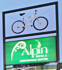
Do you think this motel is
mountain bike friendly?
I don't need any more convincing
Rotorua and the Redwoods in general
1. Rotorua is only about 3 hours drive from Auckland Airport. It's really not that far should you end up in Auckland on other business.
2. The world famous Boiling Mud and the Pohutu Geyser are located at the foot of the Redwood trails, in fact you can take the bike path from your hotel via the boiling mud pools to the trail head.
3. There are accommodation options just up the road from the trails. Some advertise as being mountain bike friendly and have features such as bike washing stations and lock ups.
4. The Redwoods Forest is quite hilly and has a MASSIVE mountain and why we will be taking the Southstar Shuttle option. From the car park to the summit is roughly the same vertical climb as the Snowgums chairlift at Thredbo. That's more than double the vertical metres of Mt Stromlo!
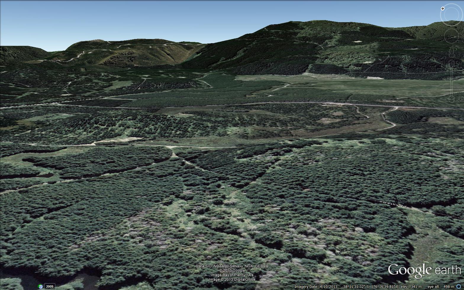
Would you look at the size of that thing !!
Click on the image to see a full size
or better still search for Whakarewarewa forest on Google Earth
The Trails
The next few points will require the assistance of this great trail map from NZO.
Click on it to see the big version.
It's not to scale but each trail is listed with a grade, length and how many metres are gained or lost along the way.

5. Find the blue trail called "Corners" it's just above the shuttle pickup point near the middle of the map in yellow. The Strava record on this 185m descent is 8-9 minutes fairly similar to the 2012/2013 Kosciszko Flow Trail at Thredbo. While the map is not to scale you can still appreciate that Corners only travels through a small section of the Redwoods forest.
6. Above Corners is "Huckleberry Hound". Huckleberry Hound and Corners together are about 5km on the descent, roughly the same length as from the top of Western Wedgetail to the car park at Stromlo (via Skyline and Luge).
a) While Stromlo descends around 190m Huckleberry Hound and Corners descends 305m.
b) The NZ trail is apparently 5km of jumps and banked corners with little respite. Thredbo's Flow Trail and Stromlo's Wedgetail, Skyline and Old Duffy have long sections of straight flat running.
c) If you take Little Red Riding Huck the trail is 2km shorter than Corners but has the same descent. That means it's going to be steep!
7. From the very top right corner follow the trails: Te Tihi-O-Tawa, Billy T, Moerangi Rd, Split Enz, Pondy DH, Pondy New, Roller Coaster and Old Chevy. That descent is around 20km. MADNESS !! So back to point 4 - its like riding from the top of the Snowgums Chairlift to Thredbo Village but on a trail that's 5 times longer than the Flow Trail and has a lot more corners .. LOTS MORE CORNERS!
Other Stuff
The map from NZO (above) has been brilliant in planning my trip but here are some other bits of gold I've found
- Trail map of the shuttled runs - Southstar Shuttled Runs Trail Map
- Route planner - OMG this is brilliant !! Ride Rotorua Route Planner
- The "Trails" sections of Ride Rotorua. I've learnt a lot about which trails to ride and which to avoid when on a tight time-frame (like Tuhoto Ariki - it looks like a descent but isn't really). Plus there are heaps of comments from other mountain bikers that I've found very helpful Ride Rotorus Trail Database
- And pretty much everything else contained within the www.RideRotorua.com website
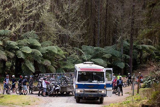
The Southstar Shuttle
What else I've learnt along the way
- I must buy a Redwoods Trail Manky, a trail map printed on a hanky - Trail Manky
- I've watched a tonne of videos and read all the magazine tips I could find on bike packing
- I've read and listened intently to all advise on customs clearance and cleaning your bike before flying! - but I still might hire a bike.
Videos to watch
- AMB Magazine's - "Mad If You Don't"
- AMB Magazine's - "Be Rude Not Too Part 1, Part 2, Part 3" (getting a little dated now)
- Flow Mountain Bike's - Ride Rotorua Top 10 Trails
- Most of the above you will find on the www.RideRotorua.com website and more
(you may have noticed the same faces appearing in these videos. Chris and Mick are living the dream!)
Rotorua by Google Maps
Trail Centres and Trails featured in this blog