
Silver Mountain Bike Park - is there a better descent in the world?
WOW - Lithium Trail - Teton Pass, Jackson Wyoming
The not so enjoyable part of Mountain Biking in Whistler
Bottom of the World - Surviving Whistler Top to Bottom
Conquering Whistler's Top of the World Trail
Fantasy Enduro - Enduro World Series Fantasy Game
Is the Thredbo AM Trail the best descent in Australia?
MTB Trail Videos - Trail Centre Upgrade Program
VIDEO: The Fourth 365 Days of Reign - My 4th year of Mountain Biking
Pilot Wilderness Ride - Cascade to Pinch - Part 2
Pilot Wilderness Ride - Cascade to Pinch - Part 1
MTB Workout for the Deskbound
Finding Bruce Ridge and Loving It!
VIDEO: Top XC Rides of 2014/2015
VIDEO: 2015 The FAIL Awakens
VIDEO: Nine Days in the Rotorua Redwoods
Exploring all of Sparrow Hill and the East Kowen Forest
VIDEO: 365 Days of Reign - The Third (year of serious mountain biking)
The New Majura Pines and Sparrow Hill Trip
Mountain Biking in the NSW Snowy Mountains
Long term test: Yakima Highroller and Whispbar roof rack
Travelling tips for Mountain Bikers
VIDEO: Giant Anthem 29er vs Giant Reign 26
VIDEO: 2014 FAILS - Will Ride, Will Fail
VIDEO: MTB-TVs TOP 10 Descents of 2014
VIDEO: The Opening of the Alpine Epic Trail - Mt Buller
VIDEO: Wrapping up the Redwoods with a Whak-en Outrageous Ride
VIDEO: Return to the Redwoods Part IV - Eagle vs Shark
VIDEO: Return to the Redwoods Part III - XC Lower Mountain Pedally Days
VIDEO: Return to the Redwoods Part II - Heavily Rooted
VIDEO: Return to the Redwoods Part I - We're Going To The Redwoods
Video: Return to Rotorua ... ok to go!
Video: Return to Rotorua ... definitely maybe!
Video: Return to Rotorua .. maybe?
Cycology - Cycling inspired clothing
Broken Bone on Breakout
Mountain Bike Fail to Triumph in the You Yangs
365 Days of Reign - My 2nd Year on a real mountain bike
Review: the Bionicon C-Guide V2.0
Brake disk rotor size upgrade 180 to 200mm, 160 to 180mm
VIDEO: Rotorua Redwoods - Create Breathing Space
Rotorua - a Mountain Bikers Journey
Summer Mountain Bike Training at OMV
2013 Another Year of #FAIL
We're going to ride the Rotorua Redwoods
My god I love riding Stromlo Forest Park
Merry Christmas from MTB-TV - What a year its been
How to view web based KML files on your mobile device
Epic Brake Bleeding Solutions - Avid Brake Bleed Kit
The Lone Wolf enjoys some group action
Bantry Bay (Northern Beaches, Sydney)
Bruce Ridge (Canberra)
Bungarra Alpine Centre (Snowy Mountains)
Currumbin Border Track (NSW/QLD Border)
Daisy Hill (South Brisbane)
East Kowen (Kowen Pine Forest, Canberra)
Forest Pipeline (Northern Beaches, Sydney)
Fred Caterson Reserve (Castle Hill)
Golden Jubilee Field MTB Park (North Shore, Sydney)
Hassans Walls (Lithgow)
Hinze Dam (Gold Coast)
Jackson (Jackson)
Jindabyne (Snowy Mountains)
Kiwarrak State Forest (Tarree)
Majura Pines (Majura, Canberra)
Manly Dam (Northern Beaches, Sydney)
Mt Joyce (Gold Coast Hinterland)
Mt Kosciuszko (Snowy Mountains)
Nerang State Forest (Gold Coast)
Newnes (Lithgow)
Old Man's Valley (Hornsby, Sydney)
Ourimbah (Central Coast)
Oxford Falls (Northern Beaches, Sydney)
Pilot Wilderness (Snowy Mountains)
Red Hill (Northern Beaches, Sydney)
Rotorua Redwoods (New Zealand)
Silver Mountain (Kellogg)
Singleton (Hunter Valley)
Sparrow Hill (Kowen Pine Forest, Canberra)
St Ives and Belrose (North Shore, Sydney)
Stromlo Forest Park (Canberra)
Terrey Hills (Northern Beaches, Sydney)
The Oaks (Blue Mountains)
Thredbo Resort (Snowy Mountains)
Thredbo Valley Trail (Snowy Mountains)
Whistler Bike Park (Whistler)
Wingello (Southern Highlands)
Wylde MTB Trail (Cecil Park - Western Sydney)
Mountain Biking in the NSW Snowy Mountains
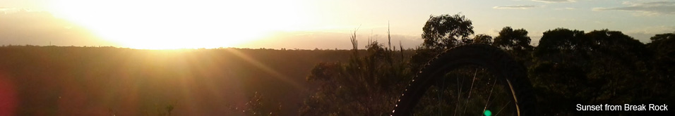
With the opening of the Australian Ski Season only days away I thought it was a good time to talk about MTBing in the NSW Snowy Mountains.
Unless you've been living under a rock you've probably heard about the progress mountain biking is making within the Australia Ski Resort industry, however when it comes to the NSW Snowy Mountains mountain biking is not just a summer sport.
This will be the 4th Ski Season in a row where my MTB will travel with me on our annual family ski trip, the purpose of this article is to encourage you to do the same.
For the sake of completeness I've included trails from Jindabyne through to all the resorts, including trails that are only summer trails PLUS information on new MTB developments in each area.
Regardless of whether you are riding winter or summer weather conditions in the Alpine country are dangerous. The temperature can drop from +30°C to freezing in no time at all, and storms have a habit of arriving before they are due.
JINDABYNE
Jindabyne Community Trail
Where: Townsend Street Jindabyne to the Jindabyne Dam
Trail: Single track (shared)
Length: 2.2km (extend with the Mill Creek Trail for 14km return)
Gradient: Pretty flat
Rated: Easy
Winter: Yes .. hell yes!
Trail Link
Notes: This is a great piece of shared single track that winds its way from the town to the dam. It's a two way track with some great banked turns and long flowy traversing sections. The trail drains really well so it's ridable all year round.
The dam end of the dirt trail has been recently reopened and it's a short ride over the dam wall and on to the Mill Creek Trail. It's a great ride with a return trip taking around 1-1.5hours depending on your fitness.
By itself the Jindabyne Community Trail is the perfect post ski ride or a must do on a rest day.
The Future: The goal is to extend the Jindabyne Community Trail right around the dam which would create a single loop of around 90km. There are still a way off achieving this however it's expected that the trail will soon extend on the western side of Jindabyne, from the end of the concrete path around the lake toward the Gaden Trout Hatchery so it can link to the extended Thredbo Valley Track (see notes on the TVT below).
Mill Creek Trail (and off shoots)
Trail: Single track (shared)
Where: From Jindabyne Dam to Rainbow Drive near the Tyrolean Village
Length: 5km (extend with the Jindabyne Community Trail for 14km return).
Gradient: Has some nice climbs from the Dam to the Tyrolean Village, one big climb on the way back. It will get the lungs working in the high altitude.
Rated: Easy/Intermediate. A few steep climbs, tight corners and odd technical feature (there are advanced off shoots)
Winter: Yes .. hell yes!
Trail Link
Notes: The Mill Creek Trail starts at the Jindabyne Dam and winds its way up to Rainbow Drive near the Tyrolean Village. The ride up has some nice steady climbs and a few steeper switchback climbs with one notable descent early in the trip. The ride back is fast and flowy with the exception of one steep climb. The trail drains very well with only few soft areas when it's wet making it very ridable in winter.
If you want to avoid the climbs get someone to drop you at the Tyrolean end and ride back to Jindabyne. It will take you 30-40mins and is mostly downhill.
The Future: The goal is to extend the Jindabyne Community Trail right around the dam which would create a single loop of around 90km. I'm told the Mill Creek Trail section would likely be the most technical section of the loop.
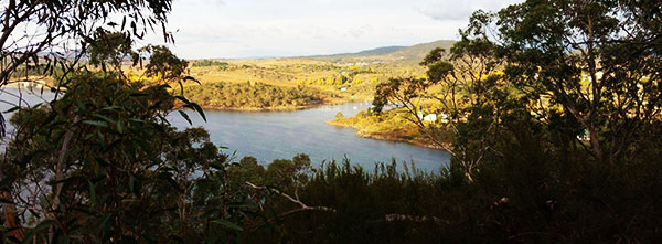
Jindabyne from the Mill Creek Trail
Bungarra Alpine Centre
Where: 5 mins drive up Barry Way from the big round-a-bout
Trail: Single Track
Length: Over 20km of single track
Gradient: Pretty flat with the exception of the black trails that have a steep gradient
Rated: Each trail is marked Green/Blue/Black. Black trails are steep, tight and technical XC trails
Winter: Closed
Trail Link
Notes: Bungarra Alpine Centre is a short drive from the centre of Jindabyne and features an excellent range of flowy and technically challenging XC trails. Trails on the eastern side of the shed tend to be flatter and winding while the trails on the western (upper) side are faster, more rocky and technical.
The climb to the top is quite a lung buster as the turns get steeper and the respite between them gets shorter. The rocks can be quite sharp so be careful on your first run.
Every time I've ridden here I've come across Kangaroos and Emus including this infamous event. GoPro Video of Mountain Bike Emu Attack.
The trails are privately owned so there are conditions of use that may restrict riding to certain days/times and may require being a club member or paying a nominal fee. Check with the locals on the current status (see locals list below)
THREDBO AND THE ALPINE WAY
Lifted Trail - Kosciuszko Flow Trail
Where: From the top of the Kosciuszko Express Chairlift at Thredbo to the Thredbo Village
Trail: Single Track (except for the craziest section of fire trail at the top)
Length: 6km
Gradient: Fast descent
Rated: Intermediate, you really want to be comfortable turning, braking and riding at speed
Winter: Closed
Trail Link
Notes: The Kosciuszko Flow Trail requires a reasonable level of skill especially when the trail is chopped up. It is a fast track with lots of braking, steep and often long turns that require reasonable commitment. There are long sections of traversing single track that will have you flying along at 30-40kph. If you aren't comfortable at high speed then expect to go through your brake pads pretty quickly and be wary of brake fade.
Lift access can be expensive however they have heavily discounted rates midweek. Consider that you may only have the energy for a few runs per day. 5 is my absolute limit with a good half hour break in between each run.
Future: A new All Mountain Trail has been built over the summer/autumn and is due to open in spring 2015. The trail build photos look amazing with some great banked corners. From information I've gathered the trail is set to run from the top of the Kosciuszko Express chairlift enabling riders to bypass the steep fire trail section at the top. The new trail will then head off from the Black Sallies Restaurant (the start of the DH and Flow Trail single track) toward the High Noon Ski Run and end up down on Friday Flat. This will open up an amazing ride from the top of Thredbo all the way down to Lake Crackenback Resort. It will be interesting to see if Thredbo change their lift ticket strategy as a result.
>> Instagram:How not to ride the Flow Trail
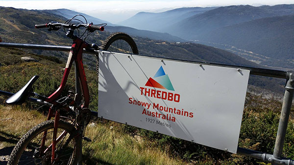
From the top of Thredbo - Kosciuszko Flow Trail
Thredbo Village Trails
Where: Around the golf course, on the eastern side of the river, around Friday Flat, the pump track and on the lower mountain.
Trail: Shared Single Track
Length: Short
Gradient: For the most part it's flat with steeper sections on the mountain side
Rated: Easy with some more technical sections on the mountain side
Winter: Trails on the mountain are closed, but other trails probably open (snow conditions permitting)
Trail Link
Note: These trails attract a lot of riders with varying skill levels, outside of ski season expect to see HEAPS of families out on the trail having a laugh. If you get out early you are likely to mix it up with the local whippets. The valley trails can be ridden on just about any bike.
Future: Details are sketchy but there seems to be a belief that some more XC trails will be built on the lower mountain linking up with the gravity and XC trails. There was plenty of work happening on the lower slopes over the Summer/Autumn of 2015 but it wasn't clear how it was all going to link up.
Thredbo Valley Track (TVT)
Where: From Thredbo (Friday Flat) to Bullocks Flat/SkiTube/Lake Crackenback Resort and Spa (LCR)
Trail: Single Track (shared)
Length: 20km (will take between 1 to 2 hours for a MTBer, 3 hours for a social rider)
Gradient: While it's a descent to LCR there are plenty of climbs along the way that total about 180m of climbing.
Rated: Easy to intermediate
Winter: The section from Thredbo to Ngarigo Campground has been closed for the 2015 winter. The lower end from Ngarigo to LCR should remain open but may get a bit boggy in places.
Trail Link
Notes: One of my favourite trails to ride. The first section from Thredbo to the Rangers Station has some really fast sections of trail. The 2nd section from the Rangers Station to Ngarigo is a great XC pedal along the western side of the river. The 3rd section from Ngarigo to Thredbo Diggings has the most technical parts including some great bridges and very tight switch back descents. The 3rd section is rated intermediate. From Thredbo Diggings there are 3 ways over the hill toward Ski Tube (Bullocks Flat) and the LCR.
- Thredbo Diggings Trail (to the left) narrow, tight in some places, has some technical sections but doesn't climb as high as the other 2 options. (Intermediate)
- Bullocks Track - TVT Part 4 (straight up the middle) Bike path, mostly wide gravel trail. A bit of a climb and descent but definitely the easiest ride for beginners (easy)
- Muzzelwood Trail (to the right) mostly single track with some fire trail that climbs up near the road. Probably the most enjoyable ride of the 3 but definitely the longest (easy to intermediate)
You can combine the three trails to make a reverse e shaped loop. From Thredbo Diggings take the Thredbo Diggings Trail, then when you reach the Ski Tube car park turn right and follow the Muzzelwood Trail up toward the Alpine way and back down to Thredbo Diggings, then take the Bullocks Track - TVT Part 4 straight up the guts back to Ski Tube. From there head to the left and under the Ski Tube Bridge before heading off around LCR.
The Future: Probably the most exciting piece of news since the TVT it itself, planning is under way to extend the TVT from Bullocks Flat all the way down the Thredbo River to the Gaden Trout Hatchery where it will come over the hill, across the Kosciuszko Rd and link up with the Jindabyne Community Trail. What we're looking at here is a trail that will run from the top of Thredbo all the way to the Tyrolean Village. While estimates vary, it could end up being a +60km single track ride with shuttles up to Thredbo from Jindabyne. Wow!
>> Instagram:Keep an eye out for walkers and other riders!
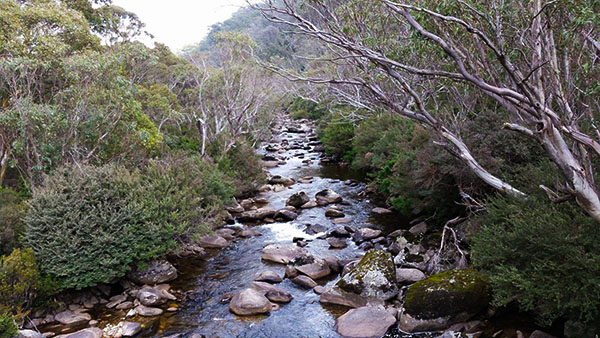
Amazing views from the Thredbo Valley Track
Lake Crackenback Resort and Spa (LCR)
Where: Off the Alpine Way just before Ski Tube
Trail: Single Track (shared watch for Segway riders)
Length: 4-7km depending on route plus another 4km of trail out along the river
Gradient: Undulating, nothing too steep
Rated: Easy
Winter: Open (depending on how boggy it is check with the LCR activities office)
Trail Link
Notes: The Lake Crackenback Resort and Spa (LCR) is a fun place to ride. It has a mix of flowy corners, pedally sections and a few skills parks thrown in. You are pretty much guaranteed to come across Kangaroos and other wildlife on this trail.
You can also head out along the River Trail for an additional 4km one way (8km return) stretch of very pretty single track consisting of green or an alternate blue trail.
The Future:LCR have a very strong activities program so expect to see further improvements on their already fun single track.
>> Instagram:Check out the size of this Kangaroo on the LCR
Lake Crackenback Resort run shuttles up to Thredbo Resort during MTB season
Pilot Wilderness
Where: From Dead Horse Gap (a few minutes drive beyond Thredbo) to various locations
Trail: Fire Trail
Length: 0-55km
Gradient: Undulating with some tough climbs expect to walk
Rated: Easy to intermediate
Winter: Probably unridable unless snow conditions are poor. Maybe Fatbike territory.
Trail Link
Notes: One of the most beautiful fire trails you will ever ride. I highly recommend riding from Dead Horse Gap to Cascade Hutand back (16km return).
For an amazing all day or overnight ride the trail goes right through the Pilot Wilderness to Barry Way almost at the NSW/VIC border. There is no phone reception on this trail and it's a long way from the end of the trail back to Jindabyne. This trek will require significant planning. Everyone who does this ride raves about it however it takes you in to the alpine wilderness so riders should be well prepared for all conditions regardless of the time of year.
Kosciuszko Rd
Mt Kosciuszko via the Summit Track
Where: From the NPWS building above Charlotte Pass Ski Resort to Rawson Hut (just short of the Kosciuszko summit)
Trail: Fire Trail
Length: 15km return
Gradient: With the exception of a short descent over the snowy river it's a reasonable climbing grade all the way up which makes for a great descent on the way back.
Rated: Easy if you have the fitness but watch for loose gravel
Winter: I suspect the snow would be too deep for even a Fatbike, but it would be an interesting challenge. You would also need to get yourself to the top of Charlotte Pass, which in itself would be a challenge. If you're really gagging to try this in winter I recommend talking to local cross country skiers and the NPWS.
Trail Link:
Notes: It's a fair slog from Charlotte Pass to Rawson Hut and in the high altitude air your lungs will be burning by the time you get to the top. The toughest part of the climb is from the Snowy River crossing up to Seamans Hut. The ride down on the other hand is fast. It took me just over an hour to climb and only 11 minutes to come down.
You can only ride as far as Rawson Hut, if you wish to climb to the summit you must do it on foot.
Riding is not permitted on other trails in this area, including the track to Thredbo, which is a shame. It would make for one hell of a ride.
Perisher, Smiggin Holes, Blue Cow and Guthega
Where: From the resorts, leading around the area and right through the mountains.
Trail: Dirt Road / Fire Trail
Length: 0-100km+
Gradient: Undulating with some really tough climbs
Rated: Easy to intermediate
Winter: Closed
Notes: I've been trying to get out on these trails for some time but the weather and other plans seem to conspire against me. I have however driven the Link Rd from Smiggins to near the Peak Chair at Blue Cow, a dirt road that's well graded.
The loop I'm most interested in doing starts at Smiggins, heads out toward the Peak Chair at Blue Cow via the Link Rd, then comes back around the mountain to Pipers Creek via the Aqueduct Trail. It's about a 10.5km ride plus another 3-4km back up the road to Smiggins.
The network of dirt roads is vast, see the next section.
Other Kosciuszko Rd Trails
There are a lot of dirt roads running off the Kosciuszko Rd, many support the various dams and hydro infrastructure. There is very little information available on these trails however they are easily spotted on Google Earth.
Some of these trails go WAY OUT BACK including trails from Guthega that eventually link up with the Alpine Way around Geehi / Tom Groggin and others that head right through the mountains toward Khancoban.
The best source of information is a NPWS booklet, available at the Jindabyne Visitors Centre, but even this source is very vague. You should only attempt these trails if you are an experienced rider and in the presence of an experienced alpine adventurer. They have he was poorly prepared and died from exposure written all over them but there would be some amazing scenery out there!
Locals List
Rolling Ground Jindabyne Maps, info and responsible for most of the trails in the area. Legends!
Sacred Ride Jindabyne Jindabyne Bike shop and a great source of info for all things MTB in the area. You can also hire quality MTBs
NPWS Visitors Centre in Jindabyne - Don't hesitate to ask for info and register your trip if you're going back country
Jindabyne MTB Club Website and join their mailing list for latest info
Bungarra Alpine Centre
Thredbo Resort - DH, Enduro and XC Bike Hire available
Lake Crackenback Resort & spa - XC Bike Hire available
Trail Centres and Trails featured in this blog
- Bungarra Alpine Centre (Snowy Mountains, NSW)
- Jindabyne (Snowy Mountains, NSW)
- Mt Kosciuszko (Snowy Mountains, NSW)
- Pilot Wilderness (Snowy Mountains, NSW)
- Thredbo Resort (Snowy Mountains, NSW)
- Thredbo Valley Trail (Snowy Mountains, NSW)