
Bantry Bay (Northern Beaches, Sydney)
Bruce Ridge (Canberra)
Bungarra Alpine Centre (Snowy Mountains)
Currumbin Border Track (NSW/QLD Border)
Daisy Hill (South Brisbane)
East Kowen (Kowen Pine Forest, Canberra)
Forest Pipeline (Northern Beaches, Sydney)
Fred Caterson Reserve (Castle Hill)
Golden Jubilee Field MTB Park (North Shore, Sydney)
Hassans Walls (Lithgow)
Hinze Dam (Gold Coast)
Jackson (Jackson)
Jindabyne (Snowy Mountains)
Kiwarrak State Forest (Tarree)
Majura Pines (Majura, Canberra)
Manly Dam (Northern Beaches, Sydney)
Mt Joyce (Gold Coast Hinterland)
Mt Kosciuszko (Snowy Mountains)
Nerang State Forest (Gold Coast)
Newnes (Lithgow)
Old Man's Valley (Hornsby, Sydney)
Ourimbah (Central Coast)
Oxford Falls (Northern Beaches, Sydney)
Pilot Wilderness (Snowy Mountains)
Red Hill (Northern Beaches, Sydney)
Rotorua Redwoods (New Zealand)
Silver Mountain (Kellogg)
Singleton (Hunter Valley)
Sparrow Hill (Kowen Pine Forest, Canberra)
St Ives and Belrose (North Shore, Sydney)
Stromlo Forest Park (Canberra)
Terrey Hills (Northern Beaches, Sydney)
The Oaks (Blue Mountains)
Thredbo Resort (Snowy Mountains)
Thredbo Valley Trail (Snowy Mountains)
Whistler Bike Park (Whistler)
Wingello (Southern Highlands)
Wylde MTB Trail (Cecil Park - Western Sydney)
Upper Cambourne (570m)
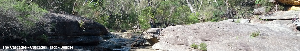
St Ives and BelroseLast Update: 24/3/2013
Some trail names are made up, if there is a different name please let us know.
Difficulty - Easy
Slope - Flat - Moderate - Steep
Space - Open
Surface - Dirt - Eternal Puddles - Loose rocks on dirt - Sand
Trail type - Firetrail
Notes:
Upper Cambourne Track runs from Cambourne Ave St Ives down to the Cascades Track (about halfway between the top and the Cascades). A short trail of less than 600m it is an alternate entrance for the main Cascade Track.
On this video I am climbing out from Cascades to Cambourne Ave.
The trail is quite steep especially at the bottom end, it's a much tougher climb than the top section of Cascades, I don't think it would be as fun to descend either as there are no waterbars and the hill is too steep to let the bike run.
The upper sections of the trail are not as steep but the track is always climbing towards Cambourne Ave.
If climbing up the hill try and hold as much momentum through the water crossing at the top because the final stretch up to the road is steep.
At the time of riding the trail was in pretty good condition with far less loose rocks than other trails in the area.
It won't be my choice of entrance or exit in the future.
About 200m from the top a trail comes in from Douglas Ave, the lower end of this trail is VERY rough with some big rocks, ruts and drops, somewhat reminiscent of the top end of Red Hill's 4WD Folly.