
Bantry Bay (Northern Beaches, Sydney)
Bruce Ridge (Canberra)
Bungarra Alpine Centre (Snowy Mountains)
Currumbin Border Track (NSW/QLD Border)
Daisy Hill (South Brisbane)
East Kowen (Kowen Pine Forest, Canberra)
Forest Pipeline (Northern Beaches, Sydney)
Fred Caterson Reserve (Castle Hill)
Golden Jubilee Field MTB Park (North Shore, Sydney)
Hassans Walls (Lithgow)
Hinze Dam (Gold Coast)
Jackson (Jackson)
Jindabyne (Snowy Mountains)
Kiwarrak State Forest (Tarree)
Majura Pines (Majura, Canberra)
Manly Dam (Northern Beaches, Sydney)
Mt Joyce (Gold Coast Hinterland)
Mt Kosciuszko (Snowy Mountains)
Nerang State Forest (Gold Coast)
Newnes (Lithgow)
Old Man's Valley (Hornsby, Sydney)
Ourimbah (Central Coast)
Oxford Falls (Northern Beaches, Sydney)
Pilot Wilderness (Snowy Mountains)
Red Hill (Northern Beaches, Sydney)
Rotorua Redwoods (New Zealand)
Silver Mountain (Kellogg)
Singleton (Hunter Valley)
Sparrow Hill (Kowen Pine Forest, Canberra)
St Ives and Belrose (North Shore, Sydney)
Stromlo Forest Park (Canberra)
Terrey Hills (Northern Beaches, Sydney)
The Oaks (Blue Mountains)
Thredbo Resort (Snowy Mountains)
Thredbo Valley Trail (Snowy Mountains)
Whistler Bike Park (Whistler)
Wingello (Southern Highlands)
Wylde MTB Trail (Cecil Park - Western Sydney)
St Ives and BelroseLast Update: 24/3/2013
For full information, including maps, photos and detailed info on trail sections use the links on the right
Notes:
This trail centre includes the trails found in the Garigal National Park between Belrose, Davidson and St Ives, and also the trails on the western side of Mona Vale Rd linking up with the trails that run around the southern edge of Terrey Hills and Duffys Forest through the Ku-Ring-Gai Chase National Park. I've been riding hard to cover all the trails in the area but there are still some more to go including the Douglas Street entrance to Upper Cambourne, the Kitchener Street entrance to the Kitchener Track, the Cooyong Track and some of the fire trails from the western end of St Ives.
Trails in this area can be easily linked with trails in the Terrey Hills and Oxford Falls area which makes them a favourite of the local long distance XC scene.
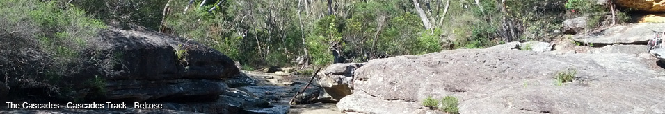
The trails that run through the valley between St Ives, Davidson and Belrose (Cascades, Heath and Bare Creek Track, Upper Cambourne, Upper Cambourne, Quarry and Ridge Top Track) are steep, to the point where some hill sections have been sealed to preserve the fire trail accessibility. If you like long descents with tonnes of waterbars then the trails in this area should keep you entertained.
In contrast the trails to the west of Mona Vale Road (St Ives Horse Track, Wildflower Gardens Single Track, Ryland, Ryland 1st Left and Ryland 2nd Left) are fairly flat and even contain some nice flowy technical single tracks (St Ives Horse Track and Wildflower Gardens Single Track).
Looking at Google Earth the fire trails that link Mona Vale Road with the trails on the southern edge of Terrey Hills (Cooyong and Sandy) contain some serious climbs. I'm looking forward to riding those.
Blog articles that mention this trail
- 17/6/2016 - VIDEO: The Fourth 365 Days of Reign - My 4th year of Mountain Biking
- 1/1/2016 - VIDEO: 2015 The FAIL Awakens
- 28/6/2015 - VIDEO: 365 Days of Reign - The Third (year of serious mountain biking)
- 29/4/2015 - Long term test: Yakima Highroller and Whispbar roof rack
- 26/1/2015 - VIDEO: 2014 FAILS - Will Ride, Will Fail
- 17/6/2014 - 365 Days of Reign - My 2nd Year on a real mountain bike
- 18/5/2014 - Review: the Bionicon C-Guide V2.0
- 1/1/2014 - 2013 Another Year of #FAIL
- 14/12/2013 - Merry Christmas from MTB-TV - What a year its been
- 28/5/2013 - Bantry Bay and Forest Pipeline trails now up
- 24/5/2013 - 365 Days of Reign - My 1st Year on a Real Mountain Bike
- 8/5/2013 - Mountain Biker Airlifted - A timely reminder about safety prep
- 16/4/2013 - Loving the Thredbo Flow Trail
- 18/3/2013 - I'm on a mission to ride the St Ives and Belrose Trails